
For much of the last two centuries, railroad lines crisscrossed Sussex County, transporting iron ore, coal, dairy products, even moonshine to population centers to the south and east. The trains stopped running decades ago, but sections of the old rail beds have been preserved as trails for bikers, hikers, joggers, dog-walkers and horseback riders. It’s a legacy not to be missed.
The Sussex Branch Trail and the Paulinskill Valley Rail Trail are woodsy, scenic, family-friendly, nicely maintained and almost entirely flat pathways through the heart of New Jersey’s northernmost county. Pick the right October weekend for a ride on either of these neighboring trails and you’ll be rewarded with a splendid foliage display—and a good workout.
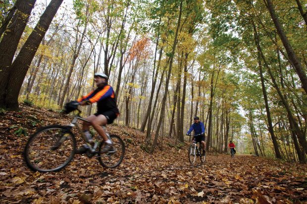
Both trails run mostly on smooth, pebbled surfaces and are suitable for hybrid or mountain bikes—not narrow-tire road bikes. Both follow the old rail beds, but require the occasional road crossing. The crossings generally are safe and simple. The Sussex Branch has one break in the trail that requires a 1.1-mile ride alongside a well-travelled county road. For that reason, the Paulinskill Trial—which follows the old right-of-way of the New York-Susquehanna and Western Railroad—is the preferred route when small riders are along.
The 27-mile Paulinskill Trail starts in Warbasse Junction, near Lafayette. (From Route 80, take Route 15 north to 94 south. Turn left on Route 663 and look for the parking area and trailhead on the right.) My companions and I check our tire pressure, strap on our helmets and plunge into the woods.
About 10 minutes into the ride we reach the first of several slate cuts blasted more than 150 years ago through large rock outcroppings to allow the trains to pass through. Here the mossy walls of slate rise in dramatic fashion 20 to 30 feet above the rail bed, creating a naturally air-conditioned passageway, but also imparting an earthy, musty odor. It’s worth a brief stop to take in the atmospheric change.
Just ahead at Route 206 we reach a major road crossing. We dismount and hoof it across the crosswalk, picking up the trail on the right side of a large parking lot.
On this day, several deep puddles and rivulets disrupt the next section of the trail. It’s nothing we can’t navigate, although our legs and bikes pick up a good smattering of mud. The cows grazing in the pasture at the edge of the trail seem amused.
Passing the marker for Halsey Station we enter the prettiest segment of the ride. Here the trail is raised on a mound, a reminder that we are riding on an old rail bed. We enter a particularly deep slate cut with walls 30 to 40 feet high. Emerging from the cut, for the next 10 minutes, we are deep in the forest. Here the woods drop away steeply to our right.
Perhaps this is a good time to mention that this is bear country. A confrontation is unlikely, as the wheels of our bikes make enough noise to alert any bears to our presence. On the other hand, we are quiet enough to encounter numerous deer, woodchucks and an array of wildfowl and avian life on and around the trail. (I take comfort in the fact that the occasional joggers we pass seem unconcerned about any ursine threat.)
After crossing a narrow road, we reach a particularly beautiful spot where Paulins Kill—a little tributary of the Delaware River that runs along much of the trail—cascades down from the hills to our left, runs under the trail and into the deep gorge to our right. Any children in tow might want to clamber down off the trail for a closer look at the gentle falls.
We reach a spot where a bridge over Route 622 is out. This makes for a little adventure. We head down a rocky pathway, cross 622 and return to the trail. We are about one hour into the ride and have reached the northern tip of Paulinskill Lake, a small private lake lined with log cabins and other vacation homes. At the south end of the lake, another bridge is out. We descend to the road on a narrow path through the woods, cross Route 614 and enter Kohlbocker Road, which leads back to the trail. A number of cars are parked on 614 at this crossing; it appears many people use this as the trailhead.
Proceeding down the trail, we reach Footbridge Park in Blairstown, another good starting point if you want a shorter version of the ride. A large public parking lot alongside the park offers entrances to the trail at either end. Riding through the lot, we pick up the trail again as it follows the banks of Paulins Kill.
We cross Route 616 and ride into little Blairstown Airport, an ideal place to take a break. This is a popular spot for small planes and gliders to take off and land. Our timing is good and we get to watch several gliders as they swoop silently over Kittantinny Mountain Ridge.
The other airport attraction is the Runway Café, a tiny retro restaurant operated by owner Jeanne Anderson and her daughter, Kim. Jeanne tells me her late husband Frank was interested in getting involved in aviation. “We ended up feeding pilots for all these years,” she says. The cafe, which delights regulars with freshmade pies and cakes, will celebrate its 30th anniversary in June.
Back on our bikes, we pick up the trail behind the restaurant and follow it along the runway until it heads back into the woods. The sun filters through the foliage to our left; on our right, a field of drying stalks undulates into the distance.
At Cross Station Road the trail seems to end, but we ride a short distance down the road to our left and pick up the path again as it heads into the woods. In no time we are in the shadows of the massive Hainesburg Viaduct, which towers more than 100 feet overhead, supported by seven mammoth concrete arches.
When built in 1910, the viaduct, which stretches 1,100 feet across Paulins Kill, was the world’s largest reinforced concrete structure. It is an awesome sight, rising high above the forest floor. Alas, its impressive arches are covered with grafitti, some unsuitable for family viewing. If you are sensitive to lewd commentary, the viaduct—while a highlight of the ride—is probably best seen from a slight distance.
Beyond the viaduct, the last mile of the trail can be swampy and impassable, so we choose this point to turn back. At our modest pace and with numerous stops, we’ve covered about 25 miles in a little more than four hours.
Families looking for shorter rides, should consider turning around at Paulinskill Lake, or just try the Footbridge Park-to-Hainesburg segment, which includes a stop at the airport. Better still, create your own shuttle by arranging your trip with an extra car and driver. Deposit that car in advance at Blairstown Airport or Footbridge Park and drive to the trailhead at Warbasse Junction. Once you reach the airport on your bikes, send sufficient drivers back in the advance car to pick up the other cars. Voila! You have a more enjoyable one-way ride.
A second alternative is to choose the Sussex Branch Trail, which is about half the length of the Paulinskill Trail—and just as enjoyable. This trail runs for about 13 miles on the old Delaware, Lackawanna and Western Railroad right of way.
The northern end of the trail can be located at a parking area on Augusta Hill Road in Branchville. (Heading north from Lafayette on Route 206, turn left at Pochuck Valley Farms.) However, the first few miles of the trail tend to be rocky and muddy. I recommend picking up the trail behind the Lafayette Mill Antique Center just off Route 15 at Morris Farm Road. There’s plenty of parking here—as well as plenty to do before or after the ride. For starters, we grab some fresh-baked munchies at the popular Millside Café.
Starting from Lafayette, we quickly reach Warbasse Junction, where the Sussex Branch and Paulinskill trails cross. From this point, the Sussex Branch is a gentle cruise under a canopy of deciduous trees for about 15 or 20 minutes until we reach the sign that alerts us to the break in the trail. Here we exit the trail and travel 1.1 miles along Route 663 (Hicks Avenue). It’s not a particularly busy rural road, but it is mostly uphill and the shoulder has narrow sections. It should not be a problem for teens and adults, but it is not a good stretch for the youngest riders.
The trail picks up again on the left just before we reach Route 616 (Sparta Avenue). After a brief stretch, we cross busy 616 and pick up the trail again at Stickles Pond Road in Andover. (This is another good starting point for a short ride, with plenty of parking.)
Just ahead is the Andover Slate Cut, the most dramatic feature of this trail. Here the trail passes through walls of slate 10 to 20 feet high. A historic marker relates the story of an 1857 snowstorm that clogged the 500-foot long crevasse until local volunteers trekked through the woods and cleared the way for the train to pass through. Once again, we stop to breathe in the mossy ferment.
The trail continues south to Kittatinny State Park. Here you can find port-a-johns, picnic tables and, for more serious mountain bikers, some challenging trails through the hills at the northern end of the park. We cruise around the park, and then jump back on the trail for several more miles to Route 206. The remainder of the trail runs mainly parallel to and within earshot of busy route 206. It’s less pleasant and more difficult to follow; consider 206 a good place to turn around and head back to Lafayette. The ride is about 10 miles each way.
Once back in Lafayette, we can’t resist browsing at the antique center, with its 50-plus dealers and surrounding shops. It’s one of New Jersey’s great antiques havens. And no one seems to object to our muddy shins.