
“Everyone must believe in something. I believe I’ll go canoeing”—Henry David Thoreau
Stop. Be silent. Listen closely. Look around. That’s spring awakening everywhere. The ground is softening, the air is warming, and the rivers are flowing with the crisp rush of the fresh thaw. It’s time to get outside.
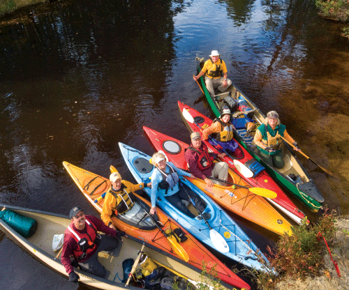
When it comes to outdoor adventure in New Jersey, few settings rival the Pine Barrens. Covering more than 1 million acres, the Pine Barrens are home to some of the most diverse wildlife on the East Coast and boast some of the most primitive and undisturbed stretches in the Garden State. Moreover, the region is a canoe and kayak enthusiast’s dream, with dozens of tucked-away rivers, creeks, and lakes brimming with rare wildlife and vegetation.
The unique tea-colored (or “cedar”) water that flows through the Pinelands is evidence of the area’s biodiversity. The water’s light-brown hue is a result of the tannic acids present in the Pine Barrens’ plant life—especially the Atlantic white cedar—as well as naturally occurring iron in many of the streams. It’s not a good idea to drink the water, but go ahead and swim all day if you’d like. You will have plenty of opportunities to do so when you begin your paddling adventure.
Perhaps the most difficult task in South Jersey paddling is sifting through the many alluring options. This guide includes insider tips on the best destinations for different skill levels, plus practical information on rentals, overnighting at various state-run campgrounds, and more. In most cases, canoe rental businesses will provide shuttle transportation to and from your start and end points.
The Mullica River: Yesterday Meets Today
In the preface to his book Jersey Genesis: The Story of the Mullica River, Henry Charlton Beck writes, “To me, the Mullica is the most wonderful of the unrecognized rivers of America.” (Click here for more suggested reading about South Jersey rivers) After just one journey down the waterway, it’s easy to see what he means. Upstream, paddlers will find deciduous forests, while downstream, the Mullica winds its way through atmospheric foggy marshes and yawning open spaces. With its wide, lazy stretches and easily navigable turns, the Mullica, which once served as a passageway for Revolutionary War supplies, is an ideal river for canoe and kayak beginners.
To traverse the entire length of the mighty Mullica would take several days and is not recommended for the novice. Instead, start at Atsion Lake on Route 206 in Shamong and travel down to Pleasant Mills. Depending on one’s skill level, this journey can take between seven and nine hours. Consider breaking it up into two short trips, paddling from Atsion to Mullica Camp (see sidebar) and then continuing to Pleasant Mills in the morning.
If you are feeling particularly adventurous, you could start your journey at Jackson Road (Route 534) in Dellette, which makes for a rewarding three-day trip. You can camp on the shores of Atsion Lake for the first night and pitch your tent at Mullica Camp the second. No matter how you parse it, the Mullica is an ideal entrée into the world of Pine Barrens paddling.
During the summer months, low water levels can sometimes plague the Mullica (particularly upstream). Make sure to get a conditions report from a local canoe-rental firm before making the trip.
The Oswego River: Sweet, Sleepy, and Scenic
At 52, Howard Chew, co-owner of Micks Canoe & Kayak Rental in Chatsworth, has been canoeing the Pine Barrens all his life. Asking Chew which South Jersey river he likes best is akin to asking a parent which child he or she loves the most. Still, Chew can’t help but lavish praise on the Oswego.
“It’s an absolutely beautiful river,” he says. “You start at a lake and end up at a lake. It can be a little difficult for beginners, with some twists and turns, but it’s just a very, very nice river.”
While not as widely known as the Mullica, the Oswego is one of the most scenic stretches of water on the East Coast. Winding its way through the Wharton State Forest, the Oswego is surrounded by an untouched landscape rich in wildlife like deer, beavers, and hawks, as well as stretches of woodlands brimming with Atlantic white-cedar swamps, lowland forests, and freshwater marshes. “People come down here and tell me it’s like therapy,” says Chew. “There’s nothing out there.”
Since camping is not permitted along the Oswego, paddlers must make this a single-day jaunt. Most journeys begin at Oswego Lake in Chatsworth just off Route 563 South and end down at Harrisville Lake off Harrisville/Chatsworth Road, a trip that takes about four hours to complete. Both lakes are ideal for picnicking and swimming.
A word of caution: Like some neighboring rivers, the Oswego is subject to frequent drops in water levels during the summer months. Sandbars can appear seemingly out of nowhere as upstream cranberry bogs cause water levels to fluctuate.
While wildlife abounds up and down all of these rivers, the Oswego has a particular reputation for beaver, red fox, and, wild turkey sightings. Keep your eyes peeled.
The Rancocas Creek: Floating Amid the Mallards
Don’t let the word “creek” fool you. While it may not be a mighty, rushing river of white water and leaping trout, the Rancocas is no slouch. Stretching for more than 30 miles, the north branch of the Rancocas winds its way through forests of maple, hickory, and oak, providing glimpses of painted and box turtles, blue herons, white-tailed deer, geese, bobcats, and squawking mallards. Like the Mullica, the Rancocas is a quintessential South Jersey paddling experience, with canoeing options for various skill levels.
The most popular stretch of the Rancocas runs from Browns Mills—which is just off Route 530 below the bridge—down to Mill Dam Park in historic Mount Holly. According to Robert Johnson, owner of RJ Toad’s Canoe Rental in Browns Mills, the entire stretch can be covered in a very long day, but beginners (and those who yearn for a more relaxed pace) would be wise to break it up into two shorter expeditions. The first leg of Browns Mills to Pemberton takes about four hours; the journey from Pemberton to Mount Holly can be done in three. Not only is this a more sensible way to travel the creek, it also matches the cool, indolent vibe of the water and the surrounding fairy-tale forests.
If you are only looking to spend a morning or afternoon on the Rancocas, there are other ways to parse the excursion. Consider a calm, relaxing float from Burlington County College to Clark’s Canoe Rental in Pemberton. That’s just three easy miles of intimate South Jersey paddling. Or perhaps put in at historic Smith Park and enjoy a wider stretch of water as you make your way down to Mill Dam Park in Mount Holly.
The Rancocas has plenty of high, sturdy shores for stops to picnic or explore, but camping along the banks is only by permission. Also worth noting, says Johnson, is that the Rancocas remains relatively deep even during the dry summer months.
In Paddling the Jersey Pine Barrens, author Robert Parnes says the origin of the Rancocas’ name is unclear. There is general agreement the creek was named after an Indian tribe, but it is uncertain which one. Both the Remkokes and the Ancocus Indians lived in the region.
The Batsto River: Gateway to the Past
“I think the Batsto River is my favorite,” says David Bel, co-owner of Bel Haven Paddlesports in Green Bank. “You get a little of everything with that river. You have narrow streams that open up into wider passages, and it tends to be a little quieter than some of the others. In some of the rivers down here you’ll see hundreds of canoes in the water during the weekends, but not so much with the Batsto.”
The Batsto originates in Tabernacle Township and runs through the Wharton State Forest all the way down to historic Batsto Village, where a dam forms Batsto Lake before a small stream finally connects it to the Mullica. It is a sojourn peppered with historical sites and gateways to South Jersey’s rich past, including Hampton Furnace, Lower Forge, and Quaker Bridge.
Ambitious paddlers can try the long stretch of the Batsto that runs from Hampton Furnace—on Hampton Furnace Road off Route 206 South—down to Batsto Lake. According to Bel, the trip can be made in eight or nine hours, but the endurance and skill required make it less appealing to novices. Instead, he says, try the shorter trip, which starts at Quaker Bridge (a tucked-away gem of a spot off Route 206 South in Vincentown) and ends at Batsto Lake.
Those who would go for the longer option might want to consider breaking up the trip into two days, stopping to camp at Lower Forge for the night, and then continuing down to Batsto Lake the following day. Be aware that Lower Forge Camp is about as primitive a camping experience as you will find in South Jersey, with no drinking water (you must carry your own) and no roads into town. “Without any cars or lights,” says Bel, “you really get that wilderness experience.”
If you are camping, get permits for Lower Forge (call 609-561-0024 or visit state.nj.us/dep/parksandforests/parks/wharton.html) and allow extra time to explore the Hampton Furnace ruins and Batsto Village.
Click here for more information about camping in the Pine Barrens.
The Salem River: The Land that Civilization Forgot
While not part of the Pine Barrens, the Salem River is an important part of the South Jersey paddling scene. At approximately 30 miles long, the Salem runs through the Supawna Meadows National Wildlife Refuge, the Mannington Meadows Complex, and the Salem River Wildlife Management Area. It is one of the largest tributaries to the Delaware River and covers more than a third of breathtaking Salem County.
Jim Waddington has been paddling the Salem for more than 30 years and still is overwhelmed by its enveloping quietude. “It’s an unspoiled vista,” says Waddington, economic development director for Salem County. “You can canoe down that river and see a few historic eighteenth-century farmhouses, but other than that, there are very few signs of human intrusion.”
According to Waddington, the trip down the Salem is fairly straightforward. It begins at Kings Highway in Sharptown (where the road passes over the water) and winds its way down to Hawks Bridge Road, where it meets a dam that is difficult, if not impossible, to cross. The entire trip can be made in less than three hours, he says. But take your time; if you are quiet, you just might spot a few falcons, osprey, and maybe even a bald eagle.
The Salem River is not tidal, so as long as water levels are cooperating, any time of day should be just fine for a trip.
Atsion Lake: Kick up Your Feet and Stay a While
Sometimes you want to keep on moving, and sometimes you just want to stay and look around for a while. If you are in the latter mood, you may want to try a relaxing and rustic visit to Atsion Lake.
This picturesque Pine Barrens lake located off Route 206 in Shamong is great for those who want a leisurely, semi-primitive lakeside camping adventure. The shores of Atsion are dotted with nine nostalgic, state-owned log cabins and 50 individual campsites. This means the Atsion experience should be enjoyed over time, not in one solitary flash. “People can just laze about on the river, come up to the shore for a swim, or even just hang out on the beach for the afternoon,” says Wayne Adams, owner of Adams Canoe Rental. “A lot of families come down for the weekend.”
At just a half mile wide and a mile and a half long, Atsion Lake is no juggernaut. Still, it can take more than two hours to paddle the perimeter. Moreover, its proximity to the Mullica and Batsto Rivers allows for plenty of outdoor diversions during your stay. “I think a lot of people are surprised when they come down here,” says Adams. “You don’t have to go to Alaska or the far, far wildernesses of Canada to get away from everything.”
The lake is pronounced “at-sign.” Before you pack the car and load up the canoes or kayaks, practice saying it out loud a few times. It will get you farther than you can imagine.
The Alloway Creek: Making Philosophers of Us All
Perhaps the entirety of the Salem River is a little daunting, and you’re in the mood for a more intimate experience. If that’s the case, try Alloway Creek. It begins as a river in Upper Pittsgrove and Pilesgrove Townships and flows westward toward the Delaware River. Five tributary branches form the headwaters of the creek, which flows into Alloway Lake, the largest in Salem County. Below the lake, the creek changes to a tidal marsh and meadow estuary; its undisturbed magnificence will inspire you to wax philosophical about the virtue of purity.
“This is not a crowded venue, so you don’t see a whole lot of other people canoeing it,” says Waddington, who has been enjoying this tucked-away spot for decades. “It’s pretty much a lazy creek. There are a lot of cutbacks in the river as it meanders. You’re going with the tide, and it’s not a very hard trip.”
Alloway Creek is tidal, so Waddington advises you check the charts before venturing out. “Ideally, you want to put in during high tide and go out with it,” he says. “That will give you about a six-hour window before you’ll experience depth issues.”
Waddington says the best spot to put in is at Route 540 in Alloway, following the creek as far as Hancock’s Bridge, a trip that takes about three hours. It’s possible to go past the bridge, but most of the land beyond that point is privately owned, making pull-outs a potentially contentious matter.
Alloway Creek provides the cooling-water intake system for the Salem Nuclear Generating Station. Throw that little bit of trivia around during your trip. It’s sure to impress.
To read more stories from our Waterfront Getaways issue, click on the links below:
Excellent! Thank you. 🙂