New Jersey’s rural byways beckon motorcyclists – and the rest of us – with stunning views, historic sites, and friendly places to hoist a pint.
In a lifetime of riding motorcycles in places as far-flung as Northern Ireland, Bosnia, Egypt, and Russia, I’ve discovered that my home state offers more variety than many an exotic locale. In a leisurely day’s ride one can experience urban intensity (Jersey City, Camden), cliffside majesty (the Palisades, western Warren County), verdant farmland (virtually any western county), and barrier island beauty (Ocean, Atlantic, and Cape May counties). Here, torn from a diary of many enjoyable Jersey rides I’ve taken in recent years, are three that stand out—however many wheels carry you along.
The North Star
Highlights: Space Farms Zoo, historic Newton, Four Sisters Winery, Morris Canal Museum
Start: Intersection of I-287 and Route 23, Butler
End: Hot Dog Johnny’s, Route 46, Buttzville
 Curving, woodsy County Road 519
starts in New Jersey’s rural northwest corner. All but the locals will need to take Route 23 to get there. That’s okay, because the commercial congestion of Route 23 fades away after it crosses I-287 in Butler and heads northwest.
Placid Charlotteburg Reservoir appears on the left as you head north on 23. Boasting some of the best fishing, canoeing, and hiking in the state, the reservoir symbolically signals the division between suburbs and truly rural communities. If you have time, two side trips beckon: the Sterling Hill Mining Museum, about two miles southwest of 23 in Ogdensburg, and High Point State Park, about 2.5 miles past 23’s intersection with 519.
But our route calls for a left onto 519 (called Brink Road locally) about six miles north of Ogdensburg. The road is conveniently marked with a sign that points to Space Farms, a 100-acre private zoo barely five miles down the road. There you will find lions, monkeys, leopards, and dozens of other animals not generally seen in a suburban cul-de-sac. A museum on the grounds holds an impressive collection of antique cars, historic weapons, children’s toys, and other assorted passions harvested since the zoo’s founding in 1927 by Ralph and Elizabeth Space and their heirs.
South of Space Farms, 519 undulates through farmland and the little settlements of Beemerville, Frankford, Branchville, and Halsey before entering Newton, the Sussex County seat. Situated along the mountain route that Washington’s armies traversed between New England and the mid-Atlantic states, Newton is packed with Revolutionary history. Along with its narrow lanes and colonial-style dwellings, Newton has some fine antique shops, and a few truly good places for lunch. One of them, Bula, features “world cuisine,” including chef Chris Priest’s Louisiana Strip Steak, with garlic mashed potatoes, zucchini, and red pepper.
South of Newton, 519 (here known as Ridge Road) climbs gradually. Fall foliage creates a virtual tunnel of color, which opens on the left at times to reveal spectacular vistas that extend, on a clear day, to the New York skyline. The road skirts several state parks as it nears the Delaware. At Belvidere, you can pull into the Four Sisters Winery (see story, page 64) to taste varietals such as Papa’s Red, based primarily on Baco Noir grapes, and Seyval Reserve, a dry oak-aged white. Most of Four Sisters’ two dozen varietals run between $12 and $15 a bottle.
You have probably been riding at least two hours, and home may beckon. Route 46, a pleasant country road in these parts, offers a piece of Americana just under a mile east of its intersection with 519 in Buttzville—Hot Dog Johnny’s, the famous drive-in.
If you have time for a final foray, follow 519 about 12 miles south of Route 46. It will bring you to the Morris Canal Museum. Located in a preserved lock house in Greenwich Township, the museum memorializes one of early America’s greatest and, sadly, least remembered feats of engineering.
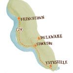
The River Run
Highlights: Washington Crossing Park, Lambertville, Delaware and Raritan Canal Park
Start: Titusville
End: Frenchtown
 My first encounter with State Road 29 was from the jump seat of a Buick station wagon packed with my siblings in the early 1970s. Mom took us all to Washington Crossing State Park in Titusville. To get there we took State Road 29, and even as youngsters we enjoyed the fine river views.
I recently rode this route from south to north, starting in Titusville, northwest of Trenton. That was a matter of convenience; reversing the itinerary would make no real difference. The federal government has designated this route a “National Scenic Byway,” and little wonder. History, natural beauty, and great little towns filled with restaurants and shops turn a relatively short ride into an excursion that easily fills a day.
In Titusville, as every American should know, Washington began the campaign that reversed the devastating losses suffered by his army in the first year of the Revolutionary War. Park exhibits and tours make the point without bragging. Besides, the 140-acre preserve and picnic tables make this a pleasant place to stretch your legs.
The road follows the river, providing views of its path. Traffic, fairly heavy in rush hour, can be light at other times and on weekends. The bends in the river, especially just south of Lambertville, offer wonderful vantage points for autumn sunsets.
Lambertville, a nineteenth-century boomtown that has shaken off the reputation of being Fort Worth to the Dallas of New Hope, just across the river, is very much worth a stop. Historically, the town benefited from its proximity to the Delaware and Raritan Canal; the wares from its factories made their way to market via barge. These days, factories have given way to shops and inns. The Bridgestreet House is one of the cozier bed and breakfasts in the region. The Stockton Inn offers gourmet cuisine. The Lambertville Antique Market is a good place to find a piece of history to take home.
Continuing north, note the steel New Hope-Lambertville Bridge, a great example of Industrial Age engineering built after the destruction of its wooden forebear in the 1903 flood. At Stockton, the steel and concrete Centre Bridge-Stockton Bridge is a utilitarian replacement for the old covered bridge that was destroyed in a fire in 1923.
What fun it would be to rumble through a covered bridge on a motorcycle—something, for all my travels, I’ve never done. I later realized that I was a short distance from the last such bridge in our state. To get there from 29 North, turn right onto Route 523 in Stockton, ride three miles, turn left on Rosemont Ringoes Road (County Road 604) in the town of Delaware. Green Sergeant’s Covered Bridge, built in 1872 to cross Wickecheoke Creek, will be hard to miss about two miles west of town.
Two miles north of Stockton, the Delaware and Raritan Canal State Park—a 70-mile-long natural corridor along the route of the old canal—offers a distinctive place to eat lunch, fish for trout, or hike. There are weekend walking tours and exhibits on the canal’s history, including the Prallsville Mills, the cluster of preserved buildings which began life in 1720 as a grist mill.
The best riding of the day awaits you on the 13-mile stretch of 29 between Stockton and Frenchtown. Heading north, trees hug the right side of the road while, on the left, stretches of low vegetation provide clear views of the river and its banks, which are particularly lush and wild here. Breezes off the river make a fall day exhilarating as the hardwoods preen in their autumn finery.
The ride finishes in Frenchtown, which offers nice art galleries and two good places to eat—the Grill Room at the Frenchtown Inn and the Ship Inn. The latter features live music on most nights, with an open mic on Tuesdays for those who can’t wait to belt out “Born to Be Wild” after a day on two wheels. Mark your calendars: The Frenchtown Wine and Arts Festival takes place Columbus Day weekend (October 10-13); the town holds its New Jersey Wine Festival every year on the first weekend in June.
One Pine Day
Highlights: Hampton Furnace, hamlets of the Pines, Radio Road, the beach
Start: Route 206 south of Mount Holly
End: Mystic Islands, Little Egg Harbor
 So much of New Jersey’s early history revolves around iron—forges and furnaces once dotted the state—that it seems appropriate to explore it on the modern version of an iron horse. I recently set out from Mount Holly determined to burrow into the Pine Barrens and find my way to the edge of the continent. Success would be defined as dipping toes into the Atlantic.
I only briefly studied a map. Figuring head south and east, eventually you’ll hit the Atlantic, I shot down Route 206 and plunged into the pinelands by hanging a left onto a gravel and dirt path called Hampton Road, just north of the Atsion ranger station. With-in five minutes, a light rain began to fall.
About three miles in, I crossed a slippery wooden bridge over the little Batsto River and found myself at Hampton Furnace, the ruins of a 300-year-old settlement that once supplied much of the region with iron. Determined not to backtrack despite the rain, I continued across another wooden bridge, and Hampton Road became Glossy Sprung Road, in Vincentown.
Once upon a time, it may have been paved, but now it is mostly sand and mud. Pintail ducks and cormorants paddled the Batsto’s tributaries, mocking my 700 combined pounds of Irishman and British steel fishtailing in the muck. I fought on for another mile, where Glossy Sprung ends in a T at Carranza Road.
Resisting the sensible urge to push south and east as planned, I took a left, remembering a dogleg that would lead me to Moore’s Meadow Road—a right about a mile north of the Carranza-Glossy Sprung intersection. Five miles down Moore’s Meadow I alighted, to great relief, on the unevenly graded but paved Ocean County Road 532, also known as Chatsworth Road.
Civilization announced itself within a mile with a sign for the Burlington County towns of South Park and Pine Crest—suddenly embraced by a 180-degree rainbow as the rain ceased. Three more miles on Chatsworth Road brought me to Chatsworth, where I headed south on County Road 563. A whiff of briny air and more signs pointed me to Little Egg Harbor, 25 miles south. The road took me through Speedwell and Jenkins. A mile past Jenkins, again following signs for Little Egg Harbor, I veered southeast onto County Road 679, following it for another ten miles until its junction with busy State Road 9.
Heading east on 9, moving fast through New Gretna, Bass River, and Giffordtown, I soon arrived at the Tuckerton Beach Grille, on South Green Street in Tuckerton—a joint recommended for seafood. It did not disappoint. I had a fantastic seafood quesadilla and a hard-earned beer.
Fueled for the final leg, I picked up Great Bay Boulevard on the south side of Tuckerton, and soon passed tidal marshes, home to flocks of waterfowl and a favorite place for crabbers. Great Bay Boulevard took me to the first of seven small bridges that connect the mainland with the Mystic Islands, which are separated by small tidal creeks. The road offers striking views of Great Bay and Little Egg Harbor.
Judging from the splats against my face shield, horseflies proliferated. Also in abundance were bumps in the road. These turned out to be turtles—a not-insignificant hazard for motorcycles—sunning themselves on the pavement. Luckily, they are indeed slow, so avoiding them is not much of a trick.
Before World War I, Germany operated a telegraph and long-wave radio station on the southernmost Mystic Island. Until the U.S. joined the war in 1917, the station’s telegraph transmissions helped alert U-boats in the North Atlantic to ships leaving local waters. Uncle Sam quickly shut down the station, and seized it as a war reparation in 1919. The station operated locally until the late 1940s. Nothing remains of it today except Radio Road, which offers nice views of the bay and a few concrete pylons that once anchored the antennas.
At last, nearly eight miles south of Tuckerton, I reached the Atlantic. A marina, a strip mall, and a marshy shoreline with lots of reeds and stones flanked a decades-old condo development. Not a pretty sight, but I didn’t mind. Such are the perils of exploration. As for the pleasures, I yanked off my boots, still caked with the sandy mud of the Pine Barrens, removed my socks, and waded gingerly into the bracing Atlantic.
Michael Moran is executive editor of CFR.org, website of the Council on Foreign Relations in New York. He lives in Nutley.
Map illustrations by Jon Cannell
If you enjoyed this article, you might also like this story about a new Motorsports Park in South Jersey. Click here to read: Making Tracks in South Jersey.