
When conservationist Benton MacKaye published an article in 1921 detailing his vision of a trail to run the length of the Appalachian Mountains, he declared that the East Coast needed a place like Yosemite or Yellowstone, where Americans could escape everyday worries and reconnect with their primeval sides.
Sixteen years later, the Appalachian National Scenic Trail—referred to as the A.T.—was first completed. The 2,190-mile footpath snakes from the northern tip of Georgia up to the center of Maine, passing through 14 states, including New Jersey.
The Appalachian Trail Conservancy (ATC) says each year, about 2,500 thru-hikers complete the entire trail, earning the title of end-to-ender. The journey takes five to seven months.
The Garden State is home to roughly 76 miles of the A.T. The path crosses into New Jersey at the Delaware Water Gap, and runs north for about 40 miles to High Point State Park before turning east. It dodges in and out of New York State before leaving New Jersey at Abram S. Hewitt State Forest.
The New Jersey portion of the A.T. is considered easy to moderate for hikers. The scenic views are spectacular, and the trail features range from dense forests to glacial lakes.
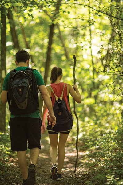
The A.T. is well marked with white blazes on trees, rocks and man-made shelters. There are some confusing turns and intersections. When in doubt, use the Google Maps app on your smartphones (we had no problem with service).
Our southbound hike covered 40 miles of trail over five non-consecutive days last summer. Each day, my companions and I arrived at the trail in two cars and left one at each end of the planned day’s hike. (Calling an Uber is not an option—we tried.)
DAY ONE: High Point State Park to Sunrise Mountain Overlook
START: A.T. parking lot, Wantage (Route 23)
FINISH: Sunrise Mountain Overlook (Sunrise Mountain Road off of Upper North Shore Road, Branchville)
DISTANCE: 8.5 miles
HIKING TIME: 3-plus hours
NEED TO KNOW: Stop at the High Point State Park Office (1480 Route 23, Sussex) to use the restroom, pick up park maps and fill your water bottles. If leaving a second car at the Sunrise Mountain Overlook lot, be sure to reach it by dusk before they lower the gates.
Like much of New Jersey’s share of the A.T., this stretch is remote and can be rough and rocky as it runs along the Kittatinny Ridge. From the Wantage parking lot, follow the connector trail to the white-blazed main trail. Around 1.4 miles in, there is a scenic overlook facing west toward the Pocono Mountains. At 2.5 miles, an open rock formation (Dutch Shoe Rock) offers a great view east over Lake Rutherford and the Wallkill Valley.
At this point, you’ll come across a short trail to the Rutherford Shelter, one of around 250 shelters along the the A.T. The stone or log shelters—with three sides and a wooden floor—are meant for thru-hikers. Many have bear boxes (for keeping food safe from bears and other creatures) and a privy, or enclosed outhouse (often without toilet paper). The Rutherford Shelter has a nearby stream; water collected here or from any stream along the trail must be treated before ingesting.
At 4.1 miles, an overlook provides another view of the Wallkill Valley. At 7.3 miles, there’s a challenging climb up a rocky incline and several stone walls. Finally, there’s a moderate incline to the Sunrise Mountain Overlook, with gorgeous views of the New Jersey Highlands and the Wallkill Valley.
Sunrise Mountain Overlook to Stokes State Forest/Culver’s Gap
START: Sunrise Mountain Overlook
FINISH: Culver’s Gap A.T. parking lot (off Upper North Shore Road, Branchville)
DISTANCE: 5.1 miles
HIKING TIME: Approximately 2 hours
NEED TO KNOW: There is a privy at the overlook and a portable toilet at the Culver’s Gap parking lot. The gates at Sunrise Mountain Overlook will close from dusk to dawn.
The scenic drive to Sunrise Mountain Overlook includes several small lots with sweeping westward views. Keep an eye out for wildlife; the area is heavily populated by bears.
Soon after starting south from the overlook, you’ll reach the circa-1930s Civilian Conservation Corps pavilion atop Sunrise Mountain. The panoramic views are impressive. At 2.4 miles, you’ll come across the Gren Anderson Shelter. Built in 1934 by the Green Mountain Club, this log shelter has water available from a spring about 200 feet away. Here, we ran into two hikers who had started their journey in Connecticut and were planning to make it to Georgia in early October. Like many thru-hikers, they went by their trail nicknames: Johnny Quest and Diva D. We talked for a few minutes as I flipped through the shelter’s trail journal. Hikers leave messages in these notebooks with their trail nicknames. The messages range from bear sightings to praise for those who leave food and water for the next hiker.
“Great hike today! Beautiful weather!” Loonie and Slug wrote on July 1, 2016. “Reminded me of home in Wisconsin on a lake. Let the adventure continue!”
As we continued our hike on what happened to be the hottest day of the summer, we reached the Culver Fire Tower. The state fire warden on duty invited us to climb to the top for a 360-degree view. The breeze above the trees was a delightful surprise.
Descending the ridgeline, we arrived back at the Culver’s Gap parking lot. We continued across Route 206 for a bite to eat at Gyp’s Tavern, a cash-only dive bar popular with hikers.
Stokes State Forest to Crater Lake
START: Culver’s Gap lot
FINISH: Crater Lake (end of Skyline Drive, Layton)
DISTANCE: 7.8 miles
HIKING TIME: Approximately 3 hours
NEED TO KNOW: There are portable toilets located at the Culver’s Gap and Crater Lake parking lots. Drivers beware: The dirt road for the last two miles to Crater Lake is heavily pot holed.
From the parking lot, follow the A.T. for a short distance before crossing over Route 206. The A.T. continues on the other side of the road. Walk toward the Route 206 sign and continue behind the guardrail to find the trail. After a short incline, you’ll reach a clearing that looks south over Culver Lake.
The trail here can be rocky at points, but it generally remains level as it continues along the Kittatinny Ridge. We were pleased to notice a complete lack of mosquitoes and ticks. On the other hand, butterflies were plentiful, and flocks of turkey vultures flying overhead were frequent companions.
At 3.5 miles, you’ll reach the Brink Road Shelter, notable for its privy—the only one along this stretch. At 4.3 miles, the crest of the ridge offers nice views west over Wallpack Valley and the Poconos; look for High Point monument to the north.
At around 5 miles, the A.T. intersects the Woods Trail shortly after entering the Delaware Water Gap National Recreation Area. The A.T. veers left (south) at the top of Bird Mountain, but it’s not clearly marked. Shortly after, at 5.8 miles, you’ll reach the summit of Rattlesnake Mountain.
Eventually, the trail descends to the base of the mountain. Cross the wooden bridge and follow the separate westward trail to Buttermilk Falls. This 1.6-mile side trip includes a steep descent to view the falls, the highest in the state.
Return to the A.T. and you’ll reach Crater Lake, once a popular vacation spot. It remains a quiet place to picnic, swim, kayak and lounge around after the day’s hike.
Crater Lake to AMC Mohican Outdoor Center
START: Crater Lake
FINISH: AMC Mohican Outdoor Center, Blairstown
DISTANCE: 9.8 miles
HIKING TIME: Approximately 3.5 hours
NEED TO KNOW: You’ll find a portable toilet at Crater Lake and an indoor bathroom with running water at Camp Mohican.
At 1.8 miles into this stretch, the A.T. crosses Blue Mountain Lakes Road. Follow the paved road west before returning to the trail. About 0.7 miles later, there is a clearing looking east over Fair View Lake. At 5.6 miles, cross the paved Millbrook-Blairstown Road and look for a gravel path, which leads to Catfish Fire Tower. About a mile after the tower (and 7.6 miles into the hike), the A.T. takes you to a rock ledge providing another panoramic view of the surrounding ridges and valleys.
Continue another 1.5 miles to Camp Mohican Road. Make a right up the paved roadway and walk to AMC Camp Mohican Outdoor Center, a welcome sanctuary for thru-hikers featuring a small store, a sitting area with couches and a fireplace, and bathrooms with running water. Hot showers cost $5.
AMC Mohican Outdoor Center to the Delaware Water Gap
START: AMC Mohican Outdoor Center, Blairstown
FINISH: Mount Tammany lot, I-80, Columbia
DISTANCE: 8.6 miles
HIKING TIME: Approximately 3 hours
NEED TO KNOW: It’s difficult to find a spot at the Mount Tammany lot (Dunnfield Creek Natural Area). Plan to arrive early. Use the restroom at the AMC Mohican Outdoor Center; there are no other facilities along this stretch.
The first 1.2 miles up to the first lookout is a bit challenging, with several steep ascents. It’s worth it. The views east over Lower Yards Creek Reservoir are stunning. At 2.4 miles, keep an eye out for the Herbert S. Hiller Plaque, a small marker to the right of the trail commemorating the devoted trail maintainer and 23rd person to earn the title end-to-ender. Soon after, look for the owl atop a pole. It’s a favorite vantage point for birders.
At 4.5 miles, you will reach Sunfish Pond, a 44-acre glacial lake surrounded by hardwood forests. It usually attracts plenty of visitors. The trail hops from boulder to boulder along the pond for the next 0.5 miles. At about 6.2 miles, you will begin the slow, sometimes rocky 2.5-mile descent to the gap.
For the last 0.5 miles of this hike, the cascades of Dunnfield Creek drown out the sounds of civilization from Route 80 as we near the Water Gap. Luckily, we saved the best for last. This day’s hike—with its open ridges and varied bodies of water and hiking conditions—was my favorite. Now I only have 2,150 miles left before I can call myself an end-to-ender.
Breanne McCarthy is a former associate editor of New Jersey Monthly. She is now an assistant editor at Monmouth University.