

Forget the hiking boots and granola bars. Walking in New Jersey requires no more than a comfy pair of shoes and a desire to enjoy fresh air and daylight. We’ve identified 18 delightful strolls throughout the state—none too long, none too steep—that everyone can enjoy.
Boulevard Trolley Line Path
Mountain Lakes (Morris County)
Start: Pocono Road and Boulevard
Distance: 2.5 miles one way
This paved path runs alongside Boulevard, the main artery through Mountain Lakes, and overlooks the town’s namesake lake, offering beautiful views of the surrounding homes. Following the bed of a former trolley line, the path is a popular route for walkers, runners and bicyclists. Impressive colonial, Georgian and Spanish-style homes flank the path, and large, mature trees provide shade, adding comfort even on the hottest days of summer. There are several free parking lots on Boulevard, or grab a spot on a side street. The path stretches to Elcock Avenue; start at either end.—SV
Branch Brook Park
Newark (Essex County)
Start: Park Avenue and Lake Street
Distance: Varies
This 360-acre expanse—America’s first county park—was formally created in 1895. The Olmsted Brothers redesigned the park in 1900, giving it a natural look similar to Central Park, their father’s most famous design. A 4-mile paved path winds through the rolling mix of meadows and woodlands. Notably, Branch Brook features America’s largest collection of cherry trees (more than in Washington, D.C.). Thousands of visitors descend upon the park for the annual Cherry Blossom Festival, starting this year on April 6. Festivities conclude April 14 with Bloomfest, an extravaganza of Japanese cultural demonstrations, live music, children’s activities, food vendors and more.—MM

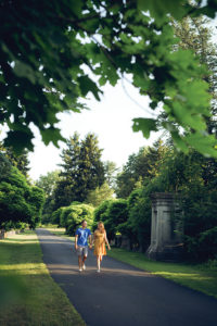
Lucy, the cocker spaniel, leads NJM managing editor Deborah Carter and her family (from left) Janelle Gera, Angela Weaver and Beatrice Willis on a shady stroll.
Photo by Marla Cohen
Brookdale Park
(Essex County)
Start: Watchung Avenue entrance
Distance: 1.2-mile loop
Another Olmsted Brothers creation, this 121-acre park, which straddles Bloomfield and Montclair, hosts summer concerts and fireworks on the Great Lawn and features a running track and 18-station fitness course. Enter on Watchung Avenue; a one-way road takes you to the first parking area. From there, a shaded, 1.2-mile asphalt walking path offers a mix of minor inclines and level ground. Walking in the direction of the vehicular traffic, you’ll pass ballfields and, on your right, a largely hidden archery field. At the top of the hill, there’s a playground on the left. You can detour onto a path into the woods past the dog park to the rose garden—a hilltop refuge with benches. Rest here and smell the more than 100 varieties of roses.—DPC
Cooper River Park
(Camden County)
Start: Parking lot near LaScala’s Birra restaurant
Distance: Varies
Opened in 1935, this 346-acre park along the Cooper River runs through Pennsauken, Cherry Hill, Collingswood and Haddon Township. The park—home to the Cooper River Yacht Club boathouse—hosts frequent rowing events and regattas. Local high school crew teams can often be seen practicing on the river on weekday afternoons. It’s also a popular area for birds and wildlife, with scenic views throughout the park. There are two designated walking paths: a paved 3.8-mile loop from Cuthbert Boulevard to Route 130, and a 1.35-mile trail from Cuthbert to Grove Street. The Philadelphia skyline views are especially striking from the bridge on Cuthbert Boulevard.—SV
D&R Canal State Park
(Hunterdon County)
Start: Bridge Street, Lambertville
Distance: 4.2 miles one way
The D&R is a 60-mile linear park following a 19th-century canal towpath that stretched from Frenchtown on the Delaware River south to Trenton and inland to New Brunswick. Start in downtown Lambertville (use the free lot next to Cavallo Park at Mt. Hope Street). Follow the dirt-and-gravel trail north along the canal past the tidy riverfront backyards of Lambertville. North of town, the surroundings open to a broad vista of the mighty Delaware. After four miles, you’ll reach tiny Stockton; about a half-mile farther are the galleries and gift shops (and public restrooms) of the restored Prallsville Mills. For a longer walk, continue three miles to Bull’s Island Recreation Area, with its modern pedestrian bridge over the river.—KS
Ricky Larcara and NJM associate editor Jacqueline Klecak take in the lush greenery at Duke Farms in Hillsborough.
Photo by Jauhien Sasnou
Duke Farms
Hillsborough (Somerset County)
Start: South Gate Entrance off Dukes Parkway West
Distance: Varies
More than 18 miles of trails await you at Duke Farms, a privately owned estate committed to conserving and protecting the environment. The varied paved, gravel and mulched paths wind through and around woodlands, meadows, lakes and waterfalls. You’ll also pass sculptures and historic buildings. Grab a map at the Farm Barn Orientation Center, located near the parking lot at the estate’s south end, and design your own route through the 2,700-acre site. No formal tours are given, but dozens of interpretive signs and audio tours are located around the property. Don’t miss the Orchid Range, filled with stunning orchids and other exotic flowers, or the Old Foundation site, where nature has taken over the remnants of an abandoned mansion. The recently restored Coach Barn was built in 1899 with locally quarried fieldstone. Admission to Duke Farms is free. No pets allowed.—SV
Fort Mott State Park
Pennsville (Salem County)
Start: Fort Mott Road
Distance: 1.1 miles roundtrip
A self-guided walking tour begins near the parking lot off Fort Mott Road. Constructed in 1896 to defend the Delaware River, Fort Mott consists of five batteries, whose guns had a range of up to 8 miles. Ladders along the length of the fort provide an elevated view of the riverfront, including Fort Delaware—on an island opposite Fort Mott—and the nearby Salem Nuclear Generating Station. The parapet, a massive concrete wall up to 35 feet thick in places, concealed the guns. The grassy trail is level, but can get muddy after a rain. Tables and grills are available for picnicking. The Welcome Center offers trail maps and a museum. A half-mile walk north of the fort is Finn’s Point National Cemetery, which contains the Civil War remains of 2,436 Confederate and 135 Union soldiers.—TW
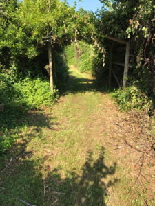
Garrett Family Preserve
Photo by Ken Schlager
Garrett Family Preserve
Cape May (Cape May County)
Start: 801 Wilson Street
Distance: Varies
This 180-acre marshland preserve—a recent project of the Nature Conservancy—is home to migratory birds, raptors, butterflies and a world of unseen, chattering insects. The Perimeter Loop is a flat, 2-mile walk on a mowed path through marshes and flowery fields. The connections with intersecting trails can be confusing, but there’s no chance of getting lost or wandering outside the loop. A series of man-made arbors at the forested northeast corner of the preserve provides the only shade; sunscreen, bug spray and a water bottle are essential. A bird blind at the southeast corner provides a view over the neighboring salt marsh. The preserve is about two miles from the Cape May beaches.—KS
Haddon Avenue Walk
(Camden County)
Start: Kings Highway and Haddon Avenue, Haddonfield
Distance: 2.5 miles one way
This sidewalk stroll takes you through three towns—Haddonfield, Haddon Township and Collingswood—past dozens of small businesses and eateries. Make your first stop at Jersey Java for a coffee or iced tea before continuing to Hooked, a yarn boutique. Peek through the windows of Acme Accordion School in Haddon Township; you might catch an accordion lesson in progress. If you’re hungry once you pass the Westmont PATCO station, stop into Heart Beet Kitchen for a bite, or if you’re in the mood for a pint, Keg & Kitchen or the Pour House offer a large selection of beers on draft. Collingswood rolls out a bounty of boutiques, galleries and restaurants. Don’t feel like walking all the way back? Hop on the PATCO and hop off two stops later in Haddonfield, a block from where you started.—SV
Henry Hudson Trail
Popamora Point (Monmouth County)
Start: 369 Shore Drive, Highlands
Distance: 1.5 miles one way
This short, scenic walk covers the easternmost section of a 24-mile trail that arcs through Monmouth County. Here the trail hugs a narrow strip of land along Sandy Hook Bay at the foot of the Atlantic Highlands bluffs. Rising steeply above one side of the trail is the highest point on the East Coast south of Maine. On the other side, the broad view across the bay can reach all the way to Manhattan on a clear day. A hidden bay beach marks one end of the trail like an exclamation point; it’s a sandy jewel. Hurricane Sandy washed away parts of the trail, but they have been rebuilt with sturdy concrete walkways across the low, wet spots. The mostly gravel trail is flat and smooth, connecting the main streets of two neighboring towns, Highlands and Atlantic Highlands, each offering plenty of food choices at either end of your walk.—KC
Photo courtesy of Lawrence Hopewell Trail Corporation
Lawrence Hopewell Trail
Pennington (Mercer County)
Start: 424 Federal City Road
Distance: 5.2 miles roundtrip
This trail has something for the engineering geek, naturalist, biker and historian, all with comprehensive signage and varied scenery. Pass Rosedale Lake, stocked with trout, and pretty Willow Pond to reach the Hunt House, believed to be a stop on the Underground Railroad, now headquarters for the county parks. From there, it’s about 1.5 miles through woods and stunning grasslands to Pole Farm, the site of AT&T’s former array of 10-story poles and antennae that enabled the first transatlantic phone calls. Side trails reach an insect walk, observation tower and stargazing area. Maps are available at lhtrail.org. Note: Deer hunters may be using bows and arrows in the park as part of the deer-management program September–to-mid-February, but not on Sundays and not within 50 feet of county trails.—TK
Middlesex Greenway Photo courtesy of Edison Greenways Group
Middlesex Greenway
(Middlesex County)
Start: Middlesex Avenue, Metuchen
Distance: 3.5 miles one way
This shaded, paved trail makes its quiet way along an old rail bed through the tangle of highways that bisect the state’s midsection. That long underpass? It runs beneath the Jersey Turnpike. That arcing bridge? It takes you over Route 1. Flat and smooth, the Greenway is a welcome respite from the bordering bustle and offers an engaging history lesson, with interpretive markers along the way. The Metuchen end gets the most use and is also home to a worthy trailside detour: the emotion-packed Metuchen Memorial Park, with 41 honey locust trees standing in straight ranks, one for each local resident who died in the wars of the last century.—KC
Natirar Park
(Somerset County)
Start: 2 Main Street, Gladstone
Distance: Varies
Park in a designated area near the entrance, then pick a path. The Upper Field Nature Trail (a 1-mile loop) features rocky sections, two steep inclines and plenty of wildflowers. The Great Meadow Trail (1.3 miles) is a much flatter journey through a scenic meadow. The North Branch of the Raritan River runs through both trails. For a map and further park information, go to somersetcountyparks.org. Looming above the north end of the 404-acre park is the Natirar Mansion, home to Ninety Acres, a fine-dining restaurant and cooking school.—DM

Photo courtesy of New Jersey State Botanical Garden at Skylands
New Jersey Botanical Garden at Skylands
Ringwood State Park (Passaic County)
Start: Parking Lot A
Distance: 1.75-mile loop
Flowering plants, forest paths, statuary, a mansion and a hidden pond are among the attractions on this walk. From the parking lot, proceed to the Carriage House for a map of the park, then turn left to pass the annual and perennial gardens. Beyond the gardens to your left, two parallel rows of crab-apple trees stretch for a half mile. Head across the crab-apple rows to reach a fenced sanctuary for hostas, rhododendrons and rock-loving plants, then follow the path to the right to Swan Pond. Turn around and recross the crab-apple rows and head for the lilac garden, which is best enjoyed in May. Terraced gardens nearby lead to Skylands Manor, a Tudor Revival mansion (guided tours on select Sundays). Circle the house to the left, enjoying the trees as you return to the parking lot with a lighter heart and lungs full of fresh air. Still feeling energetic? Ringwood Manor, also part of the state park, is a short drive away.—KL
Nomahegan Park
Cranford (Union County)
Start: Springfield Avenue lot
Distance: 2-mile loop
Located across the street from Union County College, this county park features a scenic lake bisected by a footbridge. Park in the lot near the playground (spots can be scarce on weekends) and take the paved, mostly flat path through the woods to Kenilworth Boulevard, which follows the edge of the park to Riverside Drive. At the end of Riverside Drive, a footbridge takes you over the Rahway River and back toward your starting point beyond the lake. Keep an eye out for deer, geese and turtles. The park contains ballfields, two playgrounds, a gazebo, and numerous benches and picnic tables.—MM
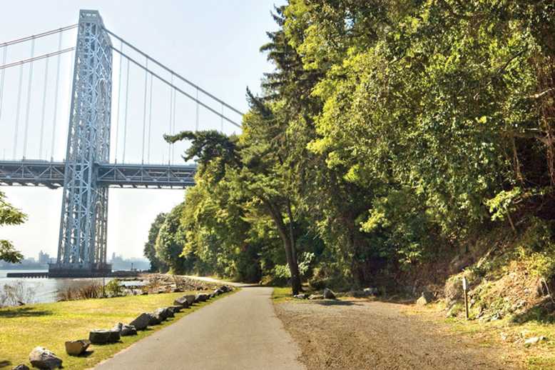
Palisades Interstate Park
Photo courtesy of njpalisades.org
Palisades Interstate Park
(Bergen County)
Start: Fort Lee Historic Park (metered parking); Ross Dock Picnic Area ($5-$10 parking, cash only); Allison Park (free parking); Englewood Picnic Area ($5 parking, cash only); or Stateline Lookout (free parking)
Distance: Varies
The Palisades Interstate Park in New Jersey is about 12 miles long. Choosing which portion to explore is the hard part. The NJ Palisades Guide App is a huge help; so is njpalisades.org. Both offer information about trails, picnic areas, parking lots, restrooms, snack stands and landmarks. Assuming you don’t plan on traversing all 12 miles, some of which are difficult, you can choose from four more manageable walks:
The 33-acre Fort Lee Historic Park is like an outdoor museum. Paved paths meander through the grounds, which contain a visitor center, historic artifacts and recreated 18th-century soldier huts.
The brick walkway around the Ross Dock Picnic Area offers sweeping views of the Hudson River, George Washington Bridge and New York City. From Ross Dock, follow the Shore Trail, a tranquil dirt path with stone steps leading to sand banks and the river. Walk for 1.3 miles to the Englewood Picnic Area. That’s where you’ll find a concession stand called the Snack Shack.
For a short stroll, stop at Allison Park, an 8-acre area with paved routes.
From the the State Line Lookout, wander down Old Route 9 W, a 1.5-mile section of highway closed to traffic. Double back to the parking lot and grab a bite at the State Line Lookout Café.
Seeking more adventure? North of the Englewood Picnic Area, the Shore Trail’s terrain changes from level to rocky. The Long Path (aqua markers) follows a woodsy, cliff-top route. There are five short trails connecting the Shore Trail and Long Path as well as the challenging boulder field known as the Giant Stairs. The police emergency number for Palisades Interstate Park is 201-768-6001.—JK
Pine Tree Trail at Round Valley Reservoir
Lebanon (Hunterdon County)
Start: South Parking Lot
Distance: 1-mile loop
This looped, multiuse trail passes through pinewoods and offers beautiful views of the glimmering Round Valley Reservoir, the deepest lake in the state. Unpaved yet well groomed, it’s the easiest trail on-site, making it especially good for children and birdwatchers. Round Valley is open year-round, but can be crowded on weekends, especially during summer. There are picnic tables just off the trail if you’d care to pack a lunch. Leashed dogs are welcome.—SV
West Windsor Trolley Line Trail
(Mercer County)
Start: West Windsor Community Park, Princeton-Hightstown Road
Distance: 5 miles roundtrip
The Trenton-New Brunswick Fast Line Trolley ran hourly between the two cities from 1902-1937; part of the old right-of-way is now a paved, flat trail suitable for walkers, bikes, wheelchairs and strollers. The northern half-mile of the trail starts to the east of the football fields in West Windsor Community Park and goes to Rabbit Hill Road. To your left, off the trail, is Grovers Mill Pond, said to be namesake of the fictional town in Orson Welles’s panic-inducing 1938 War of the Worlds radio broadcast. Turn back to the south, passing the starting point and cross Princeton-Hightstown Road at the light. Follow the trail along the road, then to the left, before the PSE&G power lines. The unshaded path runs through fields of wildflowers, wetlands and wildlife. Turn back once you reach Penn Lyle Road.—TK