
We all know New Jersey is the nation’s most densely populated state. Good thing it’s blessed with an extraordinary array of parkland and preserves where we can stretch our legs and wander amid pines and ponds, salt marshes and mountain ridges. With a tip of our caps to the local visionaries who carved out these public spaces for future generations, we present our guide to some favorite Garden State walks. (Hikes are listed roughly north to south. All are free unless indicated. Check the web for area rules and seasonal changes.)
NORTH
Allamuchy Mountain State Park
Stanhope (Sussex, Warren and Morris counties)
Difficulty: Easy to moderate
Length: Various
This 9,092-acre state park spans three counties and includes the historic Waterloo Village, a restored 19th-century canal town with a simulated Lenape village. For an easy hike, park at the Sussex Branch trailhead (Waterloo Road and Continental Drive) and follow the 3-mile trail on the old railroad bed along Cranberry Lake to Andover. If you want a more challenging hike, park at the Waterloo Road trailhead opposite Waterloo Village and follow the teal-blazed Highland Trail, a technically difficult hike with a one-mile rocky ascent to a spectacular vista overlooking the south portion of the park and the Musconetcong River. The trail eventually intersects the Sussex Branch Trail.—JB
Norvin Green State Forest
Ringwood (Passaic County)
Difficulty: Moderate
Length: 7.7-mile loop
The 10 trails here can be rugged. To create a loop, you must link up with four trails. You’ll catch such breathtaking features as Chikahoki Falls and Otter Hole. Start your hike from the Snake Den parking lot (150 Snake Den Road, Ringwood) on the paved green trail. Pick up the blue trail at the kiosk and continue steadily upward to a large, painted rock reading “Hi Point.” The arrow directs you to the red-on-white trail and Wyanokie High Point; on a clear day, you’ll have a great view of Manhattan. Farther on, take the white trail past the falls, and return to the parking lot using the blue trail to the green trail.—MM
Mills Reservation
Cedar Grove, Montclair (Essex County)
Difficulty: Easy
Length: Various
This 157-acre suburban woodland has seven poorly marked dirt and gravel trails. Not to worry; just follow the many hikers and dog walkers who frequent the park. Start from the parking lot on Normal Avenue and head up the hill, bearing left. Follow the cliffs on your left to the Quarry Point lookout. On a clear day, you can see Manhattan. The mysterious cement platform is said to be the site of a World War II antiaircraft installation. From the lookout, turn left, then right. The white, blue, yellow and red trails all take you back toward the parking lot.—KS
Pyramid Mountain
Montville (Morris County)
Difficulty: Moderate
Length: 1.5 miles one way
The well-marked blue trail starts gradually from the parking lot on Boonton Avenue, then reaches a slightly difficult rocky ascent. Once you’ve cleared that short section, it’s an easy stroll on a narrow, smooth trail to the main attraction: Tripod Rock, a tank-size boulder perched atop three smaller boulders. The Stonehenge-like formation appears to defy gravity while attracting selfies. On the walk down, use the alternative white trail for a different angle on the rocky descent to the parking lot.—KS
Jockey Hollow
Morristown National Historic Park (Morris County)
Difficulty: Easy
Length: 2.25-mile loop
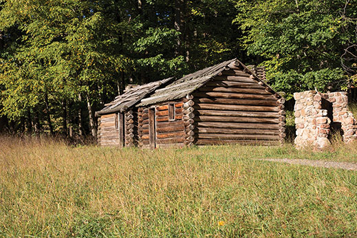
Jockey Hollow at Morristiown National Historic Park in Morristown. Photo by Laura Baer
This national treasure—minutes from downtown Morristown—is the site of the Continental Army’s encampment under General George Washington during the frigid winter of 1779-80. The yellow-blazed loop meanders through woods and meadows, passing historic landmarks, including a cluster of reconstructed log cabins with bunks—a sample of the 1,200 huts war-weary soldiers once built on the site. Feel free to walk into the huts. The trail also passes Wick Farm, a preserved 1750 homestead, complete with an active community garden. Three parking lots within the park have direct access to the yellow trail.—JB
Hacklebarney State Park
Chester (Morris County)
Difficulty: Moderate
Length: 2.5-mile loop
Most of this 1,186-acre park is designated for hunting, but the 465-acre swath north of the Black River is a scenic section of trails, fishing holes, and picnic and grilling areas. Use the main parking lot off Hacklebarney Road, then follow the red-blazed Riverside Trail down the stone steps on the left and along Trout Brook. Just after a bridge on your right marked with blue blazes, the brook tumbles into a ravine—the first of a series of small waterfalls. Follow the red trail up the hill; it eventually reaches the Black River and follows the water’s edge for roughly one mile. This portion of the trail is rocky and requires sure footing. After passing several benches—ideally positioned for enjoying the rushing waters below—the red trail merges with the white-blazed Main Trail, which loops back to the parking lot.—JB
Schooley’s Mountain Park
Long Valley (Morris County)
Difficulty: Moderate
Length: Various
Use the parking lot off East Springtown Road. Head south and branch right, walking along Lake George until it turns into the blue-blazed Falling Waters Trail. Follow the trail along Electric Brook; it starts off easy, then meanders over boulders until reaching a rock scramble. Here, you can slide on your bottom down the rocks to the base of a waterfall. Downstream of the falls, turn left at the private-property gate, and follow the trail up the mountain. It emerges at a scenic overlook (marked with a star on the trail map). For a longer round trip, the white-blazed Patriots Path from the parking lot also leads up the mountain; after the overlook, follow the signs toward the falls along the green-blazed Boulder Gorge Trail.—JB
Dickerson Mine Preserve
Mine Hill (Morris County)
Difficulty: Moderate
Length: Various
Dickerson Mine Preserve in Mine Hill. Photo by Joanna Buffum
A former Revolutionary War-era iron-ore mine site, this 280-acre public park, nestled between routes 10 and 46, offers two blazed trails and several unmarked lakeside trails ideal for scenic wandering. Park at the Mine Hill Beach parking lot at Sunset Lake (34 Green Road, Mine Hill). The trailhead is behind the playground. After passing through the gate, make an immediate left to find the orange-blazed trail, which winds up the hill into the forest along a stone pathway. It merges with the white-blazed trail, a 3-mile loop that passes the ruins of the former mine. To avoid ascending the mountain, stick to the unmarked dirt trail that meanders along Sunset Lake with several hidden sandy nooks for swimming (packed with picnicking teenagers in the summer). The unmarked trail network connects several small lakes on the edge of Randolph and Roxbury. Grab lunch after the hike at the Black River Barn, overlooking its namesake pond.—JB
Black River Park
Chester (Morris)
Difficulty: Easy
Length: 2.3 mile one-way
Park at the Cooper Gristmill visitor center on Route 24 (just past Alstede Farms when coming from downtown Chester) and walk down the wooden steps on the side of the historic water-powered 1826 mill, which offers seasonal tours and flour milling demonstrations. Follow the muddy blue-blazed Black River Trail, also part of Patriot’s Path, into the woods (this portion of the trail is level with the riverbed and floods occasionally), which follows the stream past the man-made Kay Pond and damn. The trail eventually forks: the blue-blazed trail continues to the left and reaches the Kay Environmental Center, the unmarked trail to the right continues to follow along the Black River. Take the unmarked right-hand trail; continue straight down the ravine towards the river, cross a wide wooden bridge and continue along the unmarked trail back up the other side of the ravine. After walking for five minutes or so, you’ll spot a steep stone staircase on your left that leads to a scenic riverside ruin known as Kay’s Cottage. Free admission.—JB
Loantaka Brook Reservation
Morristown (Morris County)
Difficulty: Easy
Length: Various
Swans, ducks, turtles, white-tailed deer, garter snakes, blue herons and other wildlife abound at this 570-acre reservation, complete with a playground, picnic tables, baseball fields, outdoor fitness area, and more than eight miles of paved trails through forest and wetland areas. Trails are wide, flat and easy to traverse for hikers, bikers and horseback riders. Park at the main entrance, 468 South Street.—BM
Watchung Reservation
Mountainside (Union County)
Difficulty: Moderate
Length: Various
Watchung Reservation is full of surprises, including an 18th-century cemetery, a deserted village (Feltville), and a lake, appropriately named Surprise. The 2,000-acre reservation has brooks, swamps, evergreen forests and loop trails ranging from 0.5 to 10.8 miles. Parking and restrooms are available at the Trailside Nature & Science Center (452 New Providence Road, Mountainside) as well as the Cataract Hollow Road entrance in Berkeley Heights. The Sierra Trail, the longest loop, passes the cemetery, Lake Surprise, the nature center, a scenic gorge and Little Seeley’s Pond. Accessible from either entrance, it has some steep inclines. Be sure to pick up a map first at the nature center; trails here are poorly marked and can be confusing.—BM
We like to think our 6,765-acre Glades Wildlife Refuge and 344-acre Peek Preserve (both Cumberland County) are pretty darn awesome for hiking, too! Both preserves are open every day, free of charge, to everyone. Learn more about them, plus download trail maps, at http://www.natlands.org/preserves
I’m going to throw in another Monmouth County park: Tatum Park. 6.3 miles of trails with some of the largest Tulip trees in the state. Easy trails through woods, fields and marshes. Wonderful place to spend an afternoon with Deep Cut Gardens just across the street.
I understand the emphasis on variety, but some relatively mundane hikes were included at the expense of some outstanding ones.
Two amazing hikes are on Bearfort Ridge. The northern Bearfort loop hike using the Bearfort Ridge, Ernest Walter, State Line and Quail Trails might be the single prettiest and possibly, most rugged hike in NJ. Glorious views of Greenwood Lake and the distant mountains, scenic Surprise Lake, and challenging, but always interesting terrain.
The Terrace Pond loop on southern Bearfort Ridge is also a top notch hike. Much of the same sort of terrain as the northern section, without the incredible views, but Terrace Pond is beautiful, glacial lake.
If you haven’t hikes Bearfort Ridge in NJ, you have missed out on a special experience.