


It happens every spring. Massive mounds of sand rise on the beach in North Wildwood. The mounds loom alongside the boardwalk, gray and menacing, like a rogue wave.
But the great mounds are nothing to fear. They are evidence of emergency beach replenishment, an annual ritual in this oceanfront resort. North Wildwood trucks sand from Wildwood City (which has too much) and deposits it on its own beaches (which have too little). In the weeks leading up to Memorial Day, the mounds disappear as the sand is spread and North Wildwood’s beaches are restored.
The annual beach fill is a temporary fix; it should cease after fall 2023, when the Army Corps of Engineers is expected to take over the care and feeding of North Wildwood’s beaches. At that point, the Wildwoods will become the last of New Jersey’s beach municipalities to sign on with the Army Corps for what is called coastal storm-risk management. This, experts say, will protect all of New Jersey’s ocean-facing beaches from the wrath of major storms—at least for the 50-year duration of the Army Corps deals.
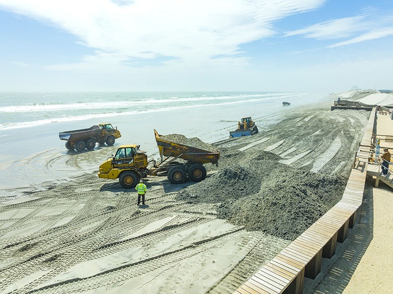
Trucks dump sand from Wildwood onto the beach in North Wildwood, where it is spread in an annual replenishment effort. Photo by Joe Polillio
“New Jersey’s oceanfront is actually in the best shape of anywhere in the country,” says Stewart Farrell, founder and director of Stockton University’s Coastal Research Center (CRC).
That’s the good news.
Now the bad: Ten years after Hurricane Sandy, the bayfronts and riverfronts of many of New Jersey’s Shore communities remain vulnerable to the twin terrors of sea-level rise and increasingly intense storms. Addressing this risk is in some ways more complicated than protecting the ocean beaches, but it is no less an issue that affects homeowners, seasonal tourism and natural habitat.
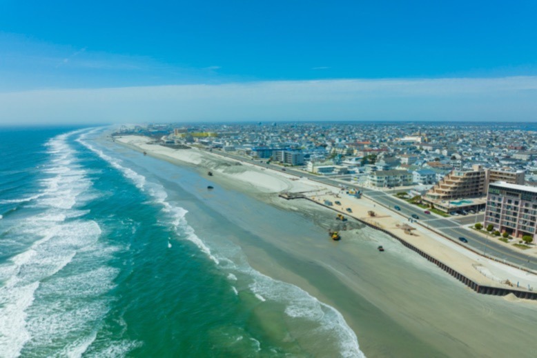
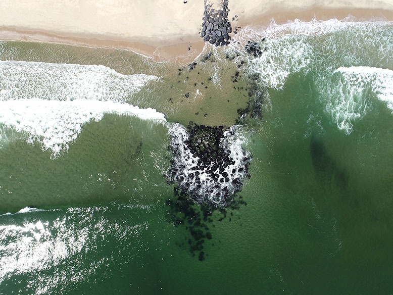
An aerial shot of Wildwood’s annual beach restoration. Photo by Joe Polillio
And the threat will only get worse. In its 2022 update, the National Oceanographic and Atmospheric Administration (NOAA) predicts sea-level rise of 10-12 inches along the East Coast by 2050. In the continental United States, only the Gulf Coast is at greater risk. What’s more, NOAA predicts that, thanks to this rise in sea level, even “moderate” flooding will occur “10 times more often than it does today, and can be intensified by local factors.”
Rising sea level is not just a 21st-century phenomenon. “Sea level was 400 feet lower 25,000 years ago,” says Farrell. As sea level rises, coastlines are pushed inland. Geologists tell us that during the Ice Age—some 20,000 years ago—New Jersey’s shoreline was probably 80 or 90 miles east of where it is today. Even in the 17th century, as early settlers began staking out Shore property, the beaches in Monmouth County were 2,000 feet farther east than the beaches we know.
Stockton University’s Stewart Farrell surveys a beach in Brigantine, where sand is abundant. Photo courtesy of Press of Atlantic City
The dominant goal for today’s coastal communities is to keep the shoreline fixed in place. That’s been the case since the late 19th and early 20th centuries, when the development of coastal resorts spurred human intervention. As the natural cycle of erosion ate away at the beaches, coastal towns created rock structures to trap sand and fend off floods. When developers turned to the bayfronts, they filled marshes and built bulkheads.
That was long before anyone could anticipate global warming. NOAA ties modern sea-level rise directly to the warming, and consequent expansion of ocean water, as well as the flow of additional water from melting ice sheets and mountain glaciers. For U.S. coastlines, the 10-12 inch rise in sea level that NOAA predicts over the next 30 years is roughly equivalent to the total increase recorded in the previous 100 years.
Further, climate scientists generally blame global warming for the heightened intensity and frequency of coastal storms, from major weather events to relatively moderate, unnamed storms that can cause what experts refer to as nuisance flooding in low-lying Shore communities.
Making matters worse, parts of the Shore, says Farrell, are sinking. That’s in part a lingering “readjustment of the land surface” to the retreat of the Ice Age glacier that once covered northern New Jersey, Farrell explains. What’s more, he says, some areas in South Jersey are sinking as we extract water from underground aquifers. Communities built on former marshes also tend to sink as the buried organic material rots away.
***
Working out of the CRC’s modest Port Republic campus in the Pinelands along Nacote Creek, 17 miles northwest of Atlantic City, Farrell and his professional staff have been tracking New Jersey shoreline changes for 35 years. In his cramped office, Farrell displays spreadsheets across two flat-screens on his desk and explains a trove of beach data from Atlantic County. Green and red spikes on Farrell’s line graphs depict shoreline movement and changes in sand volume on each beach.
On the graph for 43rd Street Beach in Brigantine, green and red lines climb steadily upward, indicating the shoreline’s seaward advance. “This has been one of the biggest gainers in the state,” Farrell says. That’s thanks to the Army Corps, which, Farrell explains, built jetties in the 1940s and again in the 1970s to protect Absecon Inlet. As well as succeeding at keeping sand out of the inlet, the northernmost jetty also captured sand for Brigantine’s neighboring beaches.
Farrell switches his screen to the north end of Atlantic City, across the inlet from Brigantine. On this graph, the pattern is different, with spikes alternately pointing up and down. The downward spikes indicate a beach starving for sand. The upward spikes? Those are the Army Corps pumping sand back onto the beach in 2003, 2013, 2014, 2017 and 2020.
Coastal engineers call this beach nourishment. Sand was pumped onto Atlantic City’s beachfront as early as 1935. As far back as 1910, sand was pumped out of Cape May Harbor onto a neighboring beach, says Stephen Rochette, spokesman for the Army Corps’ Philadelphia District, which is responsible for New Jersey’s beaches south of Manasquan Inlet.
But, says Farrell, “the real meat and potatoes” of beach nourishment happened after 1989. That’s when New Jersey started to engage in the federal Shore Protection Program. Under that program—part of the Water Resources Development Act—the Army Corps enters into 50-year deals with states and individual municipalities along America’s threatened coastlines, rivers and lakes to restore beaches and perform maintenance as needed. Cape May was the first New Jersey municipality to join the program in 1989, according to Farrell. Most of New Jersey’s other oceanside communities followed; the Wildwoods are the only municipalities that have not yet signed on.
New Jersey, says Farrell, has been “a unique winner” in the Shore Protection Program sweepstakes. Even before the advent of the federal program, the state had agreed to fund 75 percent of local beach-nourishment projects, with the locality paying the rest. Under the Shore Protection Program, the federal government committed to paying 65 percent of the cost of beach projects. That means municipalities only have to pay 25 percent of the state’s 35 percent responsibility, or about 8.75 cents on the dollar. (For some projects, the federal/state split is 50/50. “It depends when a particular project was authorized by Congress,” says Rochette.)
Jon Miller, research associate professor of coastal engineering at Stevens Institute of Technology in Hoboken, says Hurricane Sandy—which made landfall in New Jersey on October 29, 2012—made perfectly clear the value of beach nourishment. “The effectiveness of beaches and dunes in mitigating damage was one of the main takeaways from Sandy,” Miller says.
He cites Ortley Beach as an example of a community with a small beach and narrow dunes that suffered significant damage from Sandy. An even more graphic example is Mantoloking, where Sandy breached the insufficient dune system. Driven by Sandy, ocean waters sliced through Mantoloking all the way to Barnegat Bay, destroying 100 of the borough’s 521 homes.

Hurricane Sandy breached the barrier island at Mantoloking, destroying 100 of the borough’s 521 homes. Photo courtesy of Stevens Institute of Technology
More examples, Miller says, are found on Long Beach Island, “where communities that had been part of a beach-nourishment project and had some nice, healthy beaches suffered minimal damage, and then communities that were immediately adjacent [but without sufficient dunes] suffered more significant damage.”
Beach nourishment accelerated after Hurricane Sandy, in part because of the availability of Federal Emergency Management Agency (FEMA) money, which picked up 100 percent of the cost of emergency beach repairs. The agency awarded more than $2.5 billion in public assistance and grants to “restore damaged facilities and increase resiliency in New Jersey,” says a FEMA spokesman.
In the longer term, the job falls to the Army Corps. “In the Philadelphia District [from Manasquan Inlet to Cape May and the Delaware Bay] since Hurricane Sandy, the total federal and non-federal expenditures for coastal projects in New Jersey is more than $900 million,” says Rochette. A spokesperson for the New York District, including Raritan Bay and the coastline from Sandy Hook to Manasquan, did not reply to a request for similar data.

A member of a Stevens Institute student team launches a drone in Long Branch to shoot photos and collect data on shoreline changes. Photo courtesy of Stevens Institute of Technology
This past winter, the Army Corps filled beaches from the Elberon section of Long Branch to Loch Arbour, and dredged and filled in Cape May and Lower Township.
Looking ahead, Rochette says the Philadelphia District has a budget of about $106 million in fiscal year 2022-2023 for coastal projects, including “periodic nourishment” from Manasquan Inlet to Barnegat Inlet; on Brigantine Island; and in Ocean City, Avalon, Stone Harbor, Cape May City and Oakwood Beach on the Delaware Bay.
***
All New Jersey beaches are not created equal. Although not apparent to the naked eye, the Shore’s northern beaches, from Long Branch to Bay Head, sit in front of raised bluffs. These beaches slope down toward the ocean and away from the bluffs, which provide natural protection from storms for ocean-facing communities behind them. Farther north, where the bluffs end, a seawall (originally constructed in the 1930s and early 1940s by the Central Railroad of New Jersey) protects Monmouth Beach and Sea Bright.
South of Manasquan Inlet, from Bay Head to the Wildwoods, New Jersey’s beaches are on barrier spits or barrier islands, narrow strips of low-lying land with little natural protection from storms. “This is a flatter plain,” says Farrell. “It’s a slower gradient, so it floods more easily.” (Unlike barrier islands, the barrier spits are attached to the mainland.)
In the days before development, storm surges would break through the barrier islands and push sand into the back bays, creating new inlets and islands. That’s what happened in February 1920, when a sleet storm formed a new inlet at the south end of Long Beach Island. Tucker’s Beach, an early New Jersey seaside resort with two hotels and a lighthouse, was cut off from LBI, and became Tucker’s Island. Within 10 years, the island eroded, the lighthouse collapsed, and the destination was literally wiped off the map.
To prevent such disasters, New Jersey started moving rocks. Towns stacked them as seawalls to protect against erosion and floods, or piled them into long, finger-like structures that jut into the ocean to keep sand from drifting away. Commonly referred to as jetties, these fingers—built perpendicular to the beach—are properly called groins. Jetties are essentially the same, but are positioned to protect inlets from filling with sediment.
The notched groin at Marine Place in Deal allows sand to move naturally along the shoreline. Photo courtesy of Stevens Institute of Technology/Jon Miller
On New Jersey’s southern beaches, sand naturally drifts southward, driven by winter storms—those familiar nor’easters—that indeed come from the northeast. That’s why the northern tips of the barrier islands typically lose sand, while the southern ends accumulate it. Such is the case in the Wildwoods. For beaches north of Manasquan Inlet, the pattern is reversed, with sand generally moving northward.
Unfortunately, as communities constructed groins to impound sand, they deprived adjacent beaches of sand. The response was to build more groins, giving the Shore its trademark groin fields.
“New Jersey was sort of at the forefront of coastal engineering,” says Miller.
In recent years, coastal engineers have taken a more holistic approach, considering the entire Shore as a single system. They introduced new strategies and structures in an effort to create what Miller calls “coastal resilience.”
“We have all sorts of tools to model the effects of these structures,” says Miller. “The mentality has gone from stop sediment movement to control or regulate sediment movement.”
Ideally, groins would have valves to regulate the movement of sand (aka sediment). Instead, in places like Long Branch, Spring Lake, Belmar and Deal, engineers have been removing sections of groins in a process called groin notching. “The idea,” Miller explains, “is to restore some of the natural sediment movement along the coastline.”
On a grander scale, Miller and his contemporaries espouse what they call hybrid coastal environments, combining manmade structures with well-nourished beaches and dune systems, which can be reinforced by hidden seawalls or sausage-like sacks of sand called geotubes. In the event of “that really big storm, where the beaches fail, where the dunes fail, then you have another layer of protection that is provided by the structural element,” Miller says. In low-lying areas, elevated homes and infrastructure can be another ingredient in the hybrid coastal environment.
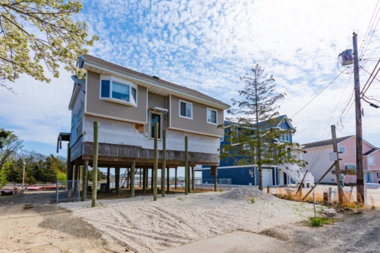
An elevated home is pictured in Mystic Islands. Photo by Joe Polillio
A number of these measures have been implemented in various communities. Even before Sandy, Bay Head had a seawall buried within its dunes. Sandy battered homes and businesses in Bay Head, but not as badly as in neighboring Mantoloking—which now has a seawall buried in its post-Sandy dunes.
Another key element in coastal resilience, says Miller, is “encouraging communities to make wise decisions in terms of where things are built and how things are built.”
Not everyone agrees with the current emphasis on refilling beaches with sand as the answer to shoreline erosion, sea-level rise and increasingly powerful storms. “We can’t pump our way out of this problem,” says John Weber, the mid-Atlantic regional manager for the Surfrider Foundation, a nonprofit environmental advocacy group.
Spending millions on beach-fill projects is merely “kicking the can down the road,” says Weber, adding, “let’s just stop now.”
As a first step, Weber says New Jersey should limit development along the coastline. “Development has only increased since Sandy…that’s just insane,” he says.
As a longer-term solution, Weber says, the millions spent on beach replenishment could be applied to buyouts of homes under the state’s Blue Acres program, which, in areas prone to storm damage, pays homeowners market value for their properties. The homes are then subject to demolition and the land is reengineered for coastline protection.
Weber says homeowners at the Shore have not taken advantage of the program, in part because the Army Corps’ replenishment projects provide “a false sense of security” that incentivizes beachfront rebuilding and development.
Miller acknowledges that some beach repairs may cease to make sense. “What will be the cost in the future?” he asks. “If in fact conditions are more erosional and we are going to have more storms that cause this erosion, can we continue to do beach nourishment?”
As another alternative, Weber favors what Miller and fellow coastal engineers call living shorelines. Miller explains: “In many cases, it’s about utilizing or trying to mimic nature in providing protection for eroding shorelines.” For example, there is a post-Sandy living shoreline in Weber’s hometown of Bradley Beach, where conservationists planted a maritime forest of dune grasses, shrubs and trees to replace an oceanside parking lot.
***
Though wrecked oceanfront homes and the marooned Jet Star rollercoaster in Seaside Heights remain the enduring images from Hurricane Sandy, it became clear after the storm that much of Sandy’s damage at the Shore could be traced to storm surge from inland waters, including Barnegat Bay, Great Bay, and the Shrewsbury and Navesink rivers.
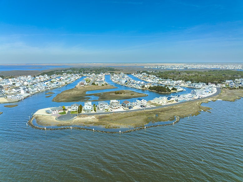
A drone’s-eye view of Mystic Islands, where many of the approximately 4,000 homes perch near the water’s edge. Photo by Joe Polillio
Mystic Islands, an unincorporated section of Little Egg Harbor Township in Ocean County, is typical of the low-lying communities susceptible to flood damage. Many of the area’s approximately 4,000 homes perch on slabs perilously close to the water’s edge; virtually all have docks in their backyards. Ray Gormley, a Little Egg Harbor committeeman, acknowledges, “All of the waterfront is in big, big trouble.”
The main artery through Mystic Islands is called Radio Road, a vestige of the area’s early days of settlement, when a German telecommunications company built a signal tower on what was then called Hickory Island. The U.S. Navy took over the tower in 1917 when America entered World War I. RCA later owned the tower and the surrounding area, but sold it to a developer in the late 1950s. Lagoons were dredged, homesites created on landfill, and two- and three-bedroom bungalows erected as summertime retreats for boating enthusiasts.
In recent years, Mystic Islands homes have grown larger and more extravagant—as have homes in most of New Jersey’s coastal communities. This spring’s listings on Zillow included a four-bedroom waterfront home marketed for $925,000.
Iowa Court dangles like the boot of Italy off the southern end of Osborn Island, one of the Mystics. When Sandy hit, the waters of Great Bay crashed over Iowa Court, flooding the dozen or so homes along the narrow cul-de-sac. “We were destroyed,” says Kris Robbins, whose little Iowa Court ranch home took on waist-deep water.
When Robbins returned after the storm, she was shocked to see refrigerators bobbing in the lagoon behind the house. “Some houses on the street collapsed,” she recalls. “We found people’s photographs in our yard from down the street.” As for her home, the siding was gone and the floors, furniture and appliances ruined.
For the CRC’s Farrell, low-lying communities such as Mystic Islands are faced with “three big choices.” They can raise everything where it sits, including streets, utilities and homes. Or they can “build a dike around everything, Holland style.”
Option 3, says Farrell, is to “walk away.” That relies on the state’s Blue Acres program, but to be effective, multiple homeowners in a cluster must take part. Farrell views Mystic Islands as “a perfect walk-away candidate.”
It’s unlikely the community’s residents would agree.
On Iowa Court, a couple of empty lots remain where homes once stood, but most of the homes have been renovated and raised or rebuilt in grander fashion. Robbins and her husband chose not to raise their place. “My husband,” she says, “doesn’t like stairs.”
Post Sandy, the road surface on Iowa Court was raised about a foot, and a rock breakwater called a marsh sill was built to help restore the marsh at the tip of the cul-de-sac. The marsh sill—built under a state grant—won’t necessarily stop the next hurricane-fueled surge from inundating Iowa Court, but it should retain sand and recreate the natural habitat on the marshy bayfront. That, says township engineer Jason Worth of T&M Associates in Toms River, should “dissipate the wave energy” from future storms.
The restored marsh at Iowa Court exemplifies a living shoreline. On bayfronts, living shorelines can include a mix of restored marshes, man-made habitat such as oyster reefs, and rock or concrete structures to act as breakwaters.
For the past decade, New Jersey nonprofits and for-profit operations have been creating habitat for shellfish throughout Garden State bays. While the shellfish help filter bay water, making the bays more hospitable to other marine life, the habitat structures help stabilize the bay floors and shorelines.
The Highlands-based nonprofit American Littoral Society, for example, has built reefs where oyster larvae can set in Barnegat Bay (at Forked River Beach in Lacey Township) and in the Delaware Bay. The reefs can “buffer against storm-driven waves,” says American Littoral Society executive director Tim Dillingham.
The concept, says Dillingham, is to “blend habitat restoration goals with this idea of coastal resiliency.”
The society has partnered on habitat restoration with institutions such as Stockton University, the U.S. Fish and Wildlife Service and the state Department of Environmental Protection (DEP). Other nonprofits working in this realm include the Barnegat Bay Partnership, the Wetlands Institute in Stone Harbor, ReClam the Bay, and, in Raritan Bay, the Hazlet-based NY/NJ Baykeeper. In addition, the society, as well as Long Beach Township and the DEP’s Marine Fisheries Administration, operate recycling programs that collect oyster shells from restaurants and deposit them in bays to create habitat for oyster larvae, fish, crabs and vegetation.
Prominent among for-profit New Jersey aquaculture operations is Barnegat Light-based Forty North Oyster Farms. Forty North’s mesh oyster bags don’t necessarily help dissipate wave impact, but the oysters raised in them contribute to clarifying the surrounding waters. What’s more, Forty North’s Matt Gregg says, the oyster larvae he cultivates can travel and set on nearby man-made oyster structures, helping them develop into naturally functioning reefs.
“There’s a lot of different approaches being tried in an effort to identify what’s the most effective both for protecting the shoreline, but also for creating some habitat,” says Miller.
Many waterfront communities filled their marshes as they developed and relied instead on bulkheads or narrow beaches to protect them from flooding and wave action, including boat wakes. These areas are vulnerable to major storms—as demonstrated by Sandy—but are also increasingly pestered by nuisance flooding. That’s the case in communities like Sea Bright and Monmouth Beach in the north, and Ocean City and Avalon to the south.
In Avalon alone, in 18 months spanning 2018 and 2019, there were 157 nuisance-flooding events, says Farrell. The vast majority of the floods were less than six inches, but in bigger storms, the floodwaters rose to three feet. “If the BMW was parked curbside at that time, it was toast,” says Farrell.
“We always think about the major storms,” says Miller. “We’re beginning to think more about the routine storms and the impact of those. Sea level plays one factor in the growing impact, potentially, but climate change in general [can play a role].”
Numerous factors complicate the search for solutions to bay and riverfront erosion and flooding. For one thing, there are many different communities with various size bulkheads and different levels of development. Local issues and attitudes must be reckoned with, as well as the need to protect natural habitat.
There’s also the question of what tactics work best. “Engineering-wise, we have the tools to be able to protect communities; it’s just a question of whether those tools are appropriate in many situations,” says Miller. “One of the challenges for a coastal engineer is to figure out what’s appropriate not only under the conditions of today, but under the conditions of tomorrow.”
Coastal engineers hope to get some of the answers from a forthcoming Army Corps back-bay study. In a preliminary release of its executive summary, the Corps acknowledges that “a paradigm shift in how we work, live, travel and play” will be required in high-risk coastal areas “as sea levels continue to rise.”
Among the tactics examined in the study are inlet and bay closures, construction of floodwalls and levees, development of living shorelines and restoration of wetlands, retrofitting (elevating) buildings, and “managed coastal retreat, including acquisition/relocation.”
Meanwhile, in Washington, D.C., a bipartisan bill introduced in February in both houses of Congress could open additional federal funding opportunities for coastal resiliency and restoration. The Shoreline Health, Oversight, Restoration, Resilience, and Enhancement (SHORRE) Act is still “very much in its early stages,” says a spokesperson for Senator Tom Carper (D-Del.), one of the sponsors.
Ken Schlager is the former longtime editor of New Jersey Monthly.